Catalina Crossing on a Hobie Tandem Island

For a long time, I had dreamt of doing adventures in our tandem kayak. After a somewhat frightening final crossing during our Channel Islands Crossing voyage, we decided to scale back kayaking the open sea. Years later, that desire to see new places came back, but I wanted a vessel that could still be human-powered, but felt more secure. That is when I discovered the Hobie Mirage Tandem Island – a boat that could be powered by pedal, paddle, and sail…

Here is a map of our most recent adventure:

This is the map for the entire route discussed in this post.  To Export GPX files, click on the three horizontal bars in the upper right hand corner of the map and select Export selected map data... To see full screen, click here (opens in new window)

There are many reasons that the Hobie Tandem Island appealed to me. For one, it could be powered by pedal. As experienced cyclists, this allows us to use our well developed muscle groups to propel the boat. On long passages, my neck would get sore while paddling the kayak whereas my legs feel like they can pedal forever. Having 3 hulls as opposed to one gives an added sense of security. Strapping on a paddle board gives you 4 “floaty things” as opposed to 1 with a standard kayak. Having a sail means that you can potentially move more quickly when winds whip up to get out of an uncomfortable situation. A kayak, on the other hand, is usually slowed by wind. Having a trimaran setup gives a lot of added confidence and stability (with the caveat that handling certain sea-states such as steep beam waves might not feel as safe as a kayak that you can adapt and roll with the sea). Finally, I was interested in pursing the option of sleeping in harbors – thereby adding sleeping options in places where it is difficult or prohibited to camp on shore. This experimental voyage answered many questions and was a baby-step towards longer sailing adventures that we have planned in the future.

Sleeping on a Hobie Tandem Island

As an experiment, I spent 3 consecutive night sleeping on my Hobie Tandem Island in the Avalon Harbor. The cost for mooring the boat were $49 per night, and I wanted to get my money’s worth out of those mooring fees! I managed this by strapping a paddle board on to one of the akas, and then erecting my tent on top of the board. It was a 3-person tent, and while the portion of the tent that was on the paddle board was well supported, the other half of the tent over the vaka was a little loosey-goosey.

Putting a tent on a Hobie Tandem Island

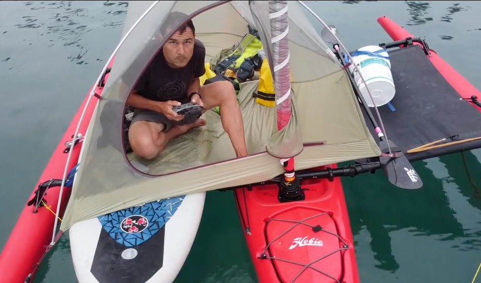
Sleeping aboard the Hobie Tandem Island. Yes, it can be done! I slept here 3 nights in a row.

I tend to be very picky about sleeping – and I also get seasick easily, so it was with great joy that I discovered I had above average sleep in the harbor in spite of bobbing around gently in every direction! This setup definitely works for me. As a result, I purchased a new paddle board that is 5 inches wider and 6 inches longer than the one in the photos (new board is 34″ wide and 10’6″ long). One could certainly come up with more elaborate sleeping platforms – including capacity for two people, but this 3 night test was enough to prove to me that it definitely works.

Camping in a tent on the Hobie Tandem Island

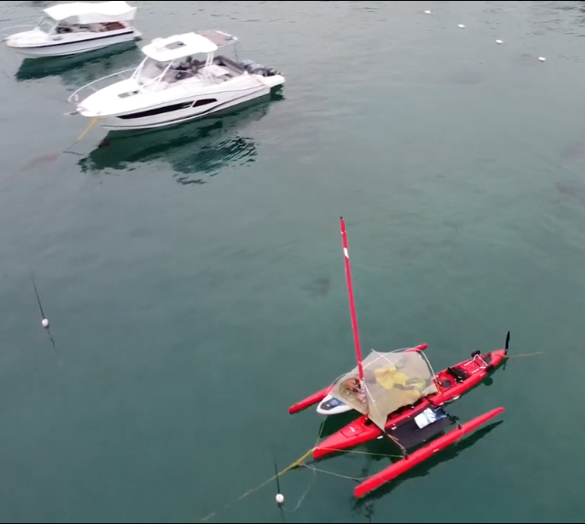
Here is an aerial view of the tent where I slept aboard the Hobie Tandem Island for 3 nights.

I came to the realization that if I were to fall off the boat in the night, that would be a deadly disaster – so I left the tent door open and the fly open (and attached to the mast) all night long. This was great for the Catalina Island climate, but it might not be suitable in locations where you’re trying to evade bugs or precipitation.

Long Distances on Hobie Tandem Island

The other thing I wanted to learn was how far can I go on the Hobie Tandem Island. Obviously, this is very dependent on winds, currents, and weather, but I found that at my “all day pace” I could average 3.5mph quite easily. The crossing to Catalina took about 7 hours each way, and both times I was happy to be done – but could have gone longer. I was able to sail the last hour or so of both crossings – dramatically increasing the speeds to about 5mph. Based on this experience, I would say that I’d be OK with doing ~25 miles in a day… but it would definitely be possible to do 30 or more – especially if you had good wind conditions. My ideal wind would be a steady 10mph wind on a “Broad Reach”. Although a Beam Reach is going to be faster, it is not quite as comfortable wave-wise as the Broad Reach. Also, once winds exceed 15mph, the sea state becomes uncomfortable in open water with a long fetch.

In the future, I hope to produce more content about things I’ve learned about this amazing craft… but for now, here you can find individual accounts for each day:

Day 1
Day 2
Day 3
Day 4
Day 6
Day 7
Day 9


Day 1:


Today went as well as I could have hoped! There were light winds, so I could sail at a comfortable speed much of the time, and relatively calm seas. Also, the visibility was good enough to safely cross the shipping channel.

Sailing is not a “fast” activity. 8mph feels really quick! Today’s major worries were fog and crossing the shipping lanes. I had researched how this works, and it turns out that boats “not under power” have the right of way. Just to be safe, I downloaded an app where I can see the boats around me - and know how to hail them on VHF in case it looks like they don’t see me. Turns out, they saw me well, and two ships made an exaggerated course alteration so within a minute, I could tell that they were going to go around me. You can buy an orange “stick” that floats and transmits a signal via VHF (range 10-70 miles) for $65… and with that alone (no subscription), my boat could appear on their maps too. Plus, I think they get a warning if they are getting too close. I noticed many smaller boats already have this tech (they were on my map)… so it is probably worth getting.

At one point, though, I was looking at this app, and when I looked up, I just started pedaling again along the course. Thank goodness for the arrows that Garmin recently added to courses… I was going exactly backwards along the course! Somehow, while I was looking down, the boat did a U-turn! Since everything looks the same, the only clue was the GPS - which I didn’t trust at first. I had 3 GPs devices running, and all 3 agreed. Oops!

Arriving at Catalina, you need to “park,” so I found the Harbor patrol guy floating in the water. We bobbed around next to each other and he assigned me a spot right next to shore - for $49 per night. Ouch! This is something I’ve wanted to do for a while, so I’m going to pay and not worry about it. They were exceptionally friendly to me (and pretty rude to the other motor guys pulling up). It was nice to get special treatment just on the basis of having a small vessel. Since we were in the ocean, I called out my phone number and he texted a link where I can pay for the parking spot.

At this point, it is calm enough to sleep on the boat, being that it is in the first row next to shore. They have lines to tie up the bow and stern, so it is pretty secure.

Now my favorite part of the day: time to meet up with Janet when she arrives on the ferry!!

Photos:


Janet and I camped out at the harbor last night. It was a nice spot with picnic tables!

Excited to finally be underway after dreaming about this trip for so long.


Here is what that app looks like. You can only see boats if you have cellular data.. but luckily the shipping lane has service. There are also more advanced devices that let you see this info beyond cell towers.


This is where those Mylar balloons go.


Due to the currents, I had to aim several degrees starboard of the destination. Thanks to GPS, this is easy if you plan a course ahead of time.


Happy to be in Avalon and thanks to Nancy for letting me borrow her SUP. This made it easy to get to land without having to mess with the boat.

Strava Comments:


Mark G.
INCREDIBLE!!! Congratulations - seriously. Your preparation and commitment is amazing.

Mark G.
Love the videos!

Mark G.
What do you estimate your actual mph to be on the crossing? And did you feel or need to adjust for currents?

Boris F.
A long and probably very satisfying day!

Scooter R.
Super cool adventure!

k K.
Congratulations!

Blake A.
thats awesome. What is the pedaling for?

Brian L.
Mark Glenesk - under pedal power, I can go 3.5 mph pretty reliably. Under sail, depends on the angle you’re headed, but was happy with 6mph. You could squeeze more speed out of it, but less comfort. I used an app called “savvy navvy” to plot the course. It it a lot like “epic ride weather” - I went North early on to have a better point of sail later in the day. App was spot on!

Brian L.
Blake Anton - unlike the America’s cup boats (which are also using pedaling to power the instruments), this is propulsion. Good to augment the wind or maneuver in close quarters. You can also páddle.

Cindy H.
Brian, so amazing! How are you getting home?

Norm S.
Did you see any creatures out there?

Randy L.
With the distance and the waves, any elevation gained?

Osman I.
This is awesome, Brian. Kudos to you! I LOVE it!!

Tony B.
You did it! You’re amazing dude. Glad you had the chance to look at the GPS and correct course. Once out in open ocean you realize how small you are.

Janet W.
Congrats on a perfect crossing! All your planning and safety tech devices, plus balmy weather made for a success crossing - and after a night with little sleep! I’m glad you had just the right amount of wind for non-scary sailing.

Santosh M.
Wow

Deb J.
Congrats!!! Amazing videos! I’m so happy that you fulfilled this dream!

Sօʀƈɛʀɛʀ 🅅.
That's pretty darn cool Brian

Marty P.
And you said that I was brave!

Stan H.
Wow! Thor Heyerdahl, Gaspar de Portolá, Ernest Shackleton, Brian Lucido!

Ride Stats:

Elapsed Time Moving Time Distance Average Speed Max Speed Elevation Gain Calories Burned
08:30:54
hours
06:15:40
hours
47.46
km
7.58
km/h
11.52
km/h
71.00
meters
1,841
kcal

Day 2:


Catalina is so close to home, you don’t need to leave the country or suffer tropical humidity… but can still have the beach vibe. Last night I went for it: sleeping in the harbor. I put Nancy’s paddleboard on the akas of the boat and put a tent on top of the 30” wide board. It worked! I did once fall off the paddle board - but towards the vaka which was better than falling the other direction. I was so tired that even with the shot of adrenaline, I fell back asleep quickly again.A seal came to check the boat out and bumped it pre-dawn. Otherwise, it was a great night.

Hiked with Janet’s swim land buddies and getting to know them better. I’m kind of crashing the ladies’ getaway. But luckily we all like the same things: hiking, swimming, and eating.

Photos:


Dawn, Nancy, Judy, and Janet.. went to the top of the mountain… to see what they could see. And We saw the other side of three mountain!

83 sleep score on a boat. Not bad!

Video of the boat on its mooring.


Snorkeling with Janet.


Video from my “camp” on the water. In the morning, people would boat over and offer me coffee. It’s a nice vibe living in the harbor.

Janet getting ready to snorkel. 🤿 Photo credit to Vicki

Strava Comments:


Mark G.
I love the photos-especially seeing the tropical looking fishes. Water temp?

Ali G.
Enthralled with the rent on the paddle board situation

Ali G.
Tent*

DogMeat Q.
I love Catalina!

Janet W.
We all had fun watching your harbor drone video! Love living the island life with you - and my five best amigas!

Judy I.
Love your tiny boat, it’s so you! And I so envy your self-confidence. I doubt I would have slept a wink, thinking of things that could have gone wrong while floating on the tiny boat zipped inside a tent. 😳⛺️ 🌊

Ride Stats:

Elapsed Time Moving Time Distance Average Speed Max Speed Elevation Gain Calories Burned
12:12:29
hours
07:06:21
hours
18.75
km
22:44
min/km
4:42
min/km
412.00
meters
1,227
kcal

Day 3:


I was surprised to discover that my island compadres did not know the meaning of “EFI” (every effin’ inch) - a term used by those over-achieving athletes who choose to do the “whole thing”, whatever that is.

I think Nancy did “Avalon EFI”. And we swam again.

Photos:


There aren’t too many different types of fish here, but it is still fun to see them. There was a rumor of the “enormous giant sea bass” (yes, it gets two adjectives). We haven’t found it though.

Bison or Buffalo? Do you know the difference? I didn’t bison are from North America.buffalo are from Asia and Africa. Oh, and this photo is a Garibaldi.

I’m posting from my tent; third night sleeping on the boat. It’s not as exciting as it was on the first night. Also, that first night, I think that the Dramamine was having a slightly intoxicating effect. So as I put up the precarious nylon structure, I felt like “who cares?” Last night, however, I thought, “I gotta be careful!” Also, tonight there are a lot more people here. You can hear the guys talking over beers saying “eff this and eff that”. They sound like they are trying to be cool, bragging about their stock portfolios. I mean, how great can your portfolio be if you’re bobbing around in the peewee size boat section like me?Definitely a different vibe than the last two nights.

Janet, Dawn, and Nancy on stage 1 of EFI.

Avalon pet cemetery.

I gave Vicki my camera to take pictures of fishies, but mainly she got photos of sea mammals.

Strava Comments:


Joffrey P.
TIL EFI

Janet W.
Last night you went from our Fairweather Cottage in town party to the swaying boat harbor scene!

Ride Stats:

Elapsed Time Moving Time Distance Average Speed Max Speed Elevation Gain Calories Burned
04:47:32
hours
03:58:16
hours
10.93
km
21:49
min/km
5:51
min/km
143.00
meters
672
kcal

Day 4:


Well, it turns out that joining in on the “girls” trip was really fun. Thanks to Janet’s friends for being so welcoming and friendly to the guy who wore the same clothes 4 (now 5) days in a row.

Janet and I had a fantastic sail to this secluded cove that felt like a true remote island getaway—well, as long as you could ignore the occasional speedboat motor. The real kicker: Camping fees. Nothing screams “untouched, unspoiled nature” like having to pay for the privilege of pooping in a ziplock bag to pretend you're alone in the wilderness. It’s amazing how much solitude costs these days—almost as much as a room at a hotel with room service.

At camp we saw a skinny little fox 🦊

Janet and I are definitely not the type of people to do a “sit on the beach and relax” vacation, but the boat comes with seats that have fold out legs - so we sat on the shore and drank our one Michelob Ultra. Too bad we don’t have more, cuz we both kinda liked it!

Photos:


Strava Comments:


Glenn O.
Sounds fantastic! More sailing trips in the future!? Did you see any dolphin or whales?

Braden L.
You definitely earned at least 2 and a bit better quality of beer in my opinion.

Ann L.
Beautiful blue water. You had to split the beer!🍺

Vicki C.
Great pictures, both over and underwater. It was fun to have you join up and I never realized you were wearing the same clothes until you told on yourself 😁

Nancy P.
Our clothes came over in suitcases and we didn’t paddle them over either 😉and didn’t notice either!! How are the campsites delineated so you know which one is yours? Hopefully will see photos of your neighbors in future posts?

Janet W.
I Nancy Prier you always ask good questions. The beaches have sign posts with the numbers. At Goat beach camp there was a big rock between us and our neighbors so we had some privacy. They were good kayakers coming from Two Harbors. I hope it’s calm again for their return.

Brian L.
Glenn Ohler - neither! But there are still opportunities. Not 100% sure how excited I would be to see a whale nearby, given the size of our vessel. 🐳

Glenn O.
I completely understand about seeing a whale - Kass and I had a whale and her calf swim under us while we were paddleboarding at Refugio a few years ago - amazing experience, but it kinda freaked me out!

Ride Stats:

Elapsed Time Moving Time Distance Average Speed Max Speed Elevation Gain Calories Burned
03:07:53
hours
02:48:27
hours
15.76
km
5.61
km/h
8.18
km/h
58.00
meters
682
kcal

Day 6:


We had some more wind today; I think it was slightly more than predicted - but pretty close. Just to be cautious, we landed at Rippers cove (thinking we might camp here because the wind was starting to scare us)… There was a guy on the beach who assured us that from the quarry to Blue point, it would be more protected. He was right, and This ended up being good practice landing and launching again - and we used the anchor successfully to sit in the anchorage and relax and plan out the next leg. Off to two harbors! The booking process is tricky; we couldn’t make a reservation online anymore because it was for today - so we made one on the phone. Only problem is that she gave us the wrong day AND the wrong site! Someone was in our site. We called back and they fixed the reservation… except there was still a tent in our site. With a bit of relief, an apologetic guy arrived at 3:00 pm to start cleaning up. We said NO WORRIES! Because now WE weren’t worried anymore 😆. Time to treat ourselves at the bar! Now I know why sailors enjoy drinking. 😉

Today was entirely into the wind and into the current. In spite of that, we made great time. Janet did a lot of the sailing too while I counterbalanced on all of the starboard tacks.

Photos:


Last view from camp. Looks like a good day!

We landed at Rippers cove, but decided to keep going after talking to a knowledgeable guy on the beach.


Bird rock? We Monitor channel 16 while underway. The idea is that you listen to this channel and other people can radio you and you can hear coast guard announcements. Once you make contact, you can agree to switch channels to free up 16. Anyway, 2 days ago we heard the coast guard asking anyone nearby to help a boat that burned up about 10 miles north of bird rock. They did not have GPS coordinantes for the distressed vessels. We finished our day without finding out. We were too far away to help at the time.


Really, Catalina is pretty awesome!

Strava Comments:


Brandon B.
Hey Brian- are you still doing Lantus/low carb? I am caving to the pump- kinda run out of ideas for myself

Brian L.
Brandon Baker - good question. Definitely trying to go as low carb as possible… except I came back from Africa eating a crappy diet, and still managed a 5.2% A1C… and I decided to live a little more and not be QUITE so strict. Still, very low carb by most standards. Apart from that MDI works well with my “low tech for important stuff” mindset. Lantus and Humalog working well. Why are you switching things up?

Glenn O.
Loving your spirit of adventure!🙌

Nancy P.
Sailing and drinking 🤣 loved seeing Janet Wagner peddling the boat and zipping along ⛵️

Paula G.
I must say, I didn't expect to like your sailing adventures. I've always been scared of the ocean. After seeing your pictures (especially the videos accompanied by music) I'm beginning to like it. 'Come sail away' Brian and Janet!

Donna K.
You guys are sooooo impressive!

Ride Stats:

Elapsed Time Moving Time Distance Average Speed Max Speed Elevation Gain Calories Burned
05:02:31
hours
03:26:34
hours
20.76
km
6.03
km/h
11.79
km/h
351.00
meters
880
kcal

Day 7:


Sunset magazine claims that Little Harbor is one of the top ten most beautiful campgrounds in the US. And we should definitely trust “the magazine dedicated to the ‘western lifestyle’”… complete with articles about home decor and growing herbs, right?

Janet and I had originally planned to schlep the boat across the isthmus and camp at this glorious spot… but then we got a better idea: leave the camping gear at our Two Harbors campsite and do an out-and-back. This turned out to be the best choice! When we arrived, the Little Harbor camp was beautiful… but in this “remote wilderness campsite” were a couple moving vans and the din of a gasoline powered generator! Apparently, a crew had come and set up tents for a large glamping group and they were in the process of setting up buffet tables. Not what we were looking for.

Another reason it was good that we left the camping gear is that the tires fell off the cart wheels several times due to the weight of the boat. A lot of this Hobie stuff is designed as if you took a dozen NASA employees and tasked them with filling the shelves of a discount toy store: Making stuff engineered to fail in a spectacular way.

Janet and I came up with various Luddite solutions to the problem; mainly taking the weight off the cart and loading it onto our bodies like beasts of burden.

At the Little Harbor beach, the only people we saw on this South/West side of the island were a couple in a dinghy with their dog. A conversation revealed that they had sailed for 15 years, including a trip from California to French Polynesia, Hawaii, and then back to Santa Barbara.

“Was it scary being so far offshore?” I asked.

“No! It was fantastic. That is the least scary part. There is nothing to run into! It’s much harder navigating harbors and shallows.”

This triggered a bit of wanderlust as we daydreamed our way back to Two Harbors.

Photos:


After the foam tire rolled off the rim the first time, we tried having Janet pull and me carry the amas.

What is this? A sack of shit. 💩 I found a deal on Amazon for these poo bags at $3 each… but you can pay $7 per bag if you’re not a savvy shopper. All that for a bag you’re going to poop in. We had brought a 5 gallon paint bucket with a rubber gasket to carry our food above the deck. Each morning, we dumped the food into the tent and lined the bucket with a bag and did our doody. On a scale of one to awful, I’d say it was about a 2. A number two. After the morning business was complete, we removed the bag and its liner and put the food back in the bucket. 😋

The backside of the island. Looks like Middle Earth.

Video clips from today. !!


I had always wanted to swim in the deep. Near the shore, the waves kick up the sand and making the water turbid. Janet agreed to let me jump out and swim. I loved the clarity, which is unlike anything I had experienced close to shore.

Our treat for all our hard word: a bad man.


Life finds a way!


Scenes from the night before. We brought 5 cache batteries, and they were mostly full… but since there is an outlet here, it was an excuse to get prepared food and drinks. 🍹

Poor Janet! This is from the day before, but while at little harbor, Janet was eating a piece of mango… that happened to be appealing to a nearby wasp at that same moment. Janet bit the wasp, and it got her back by magically turning her into a chipmunk! Her lip is now swollen, but we went to the store (behind this photo) and got her some Benadryl. 🐝 🐿️

Strava Comments:


Janet W.
I’m happy to be your 1st mate and make sure each adventure happens, no matter the effort!

Mark G.
Beautiful photos. The drone gives us quite a good overall view. What...no pictures of the glamping team? I am sure you are watching the weather windows for your return. Is Janet helping pedal back?

k K.
Wonderful pictures and story. What an Adventure!

Brian L.
Mark Glenesk - Janet is going to join me for the return trip! I think we will pedal 4/5 of the route and be able to ail the last 1/5. We are looking forward to it… but sad to be leaving this awesome island.

Greg M.
Nice weather for the Hobie !

Nancy P.
I loved seeing how the pedals propelled the boat forward from your underwater shots. Looks a bit like vertical flutter, kick with fins!

Ride Stats:

Elapsed Time Moving Time Distance Average Speed Max Speed Elevation Gain Calories Burned
10:50:35
hours
03:23:34
hours
28.96
km
8.54
km/h
10.44
km/h
2,106.00
meters
1,679
kcal

Day 9:


All great journeys must end. This was sad for me because this Catalina trip has been one of my favorites! Crystalline water and lots of time with Janet left me wanting more. Janet agreed to join me for this return crossing, where everything went exactly according to plan. Uneventful is a little boring, but for crossings, that is a good thing.

Photos:


Ahh, island time. No hands on the clock. At 5pm every day, in Avalon as well as Two Harbors, gunshots were fired and horns were blown. I think this meant, “it’s 5 o’clock somewhere.” Time to crack open a beer.

Or crack open a Diet Coke if you’re cute Janet.

We left Catalina right between nautical and civil twilight. We made good speed “motor sailing”. When you pedal, you create a small amount of wind, and it’s actually slightly faster with the sail up (believe it or not. I’ve tested this). We took a more Northward trajectory for the first 6 miles when the air was light, hoping for an easier point of sail on the remaining 19 miles.

Visibility was decent for the first half of the crossing.

Fog began to thicken after we passed the middle. This is me pointing out a dolphin. Janet and I both had an app open which allows us to see vessels who are using AIS. Even when we were within 1.5 nM of a ship, we couldn’t see it! We know the headings and velocities of the ships on the app, and we also know our own heading and speed…. So we could figure out if we were going to collide. We had 3 cargo ships we were paying attention to: La Bamba, Oocl Genoa, and Ever Focus. We never visualized any of these, even though we came within 2 miles of Ever Focus and La Bamba.

Here is the view on the Savvy Navvy app. It is by far the greatest app out of the dozen I tried. You tell it your start and finish points… the capabilities of your vessel under sail and “motor”, and it will factor in wind, currents, and depths to guide you on the optimal route. Another useful feature is that you can monitor ship traffic (see the green ship ahead of us). You can get their name and hail them on the radio if needed. Also, the circles indicating distance are very helpful because you know how far everyone is from you in all directions. In this shot, we are crossing the shipping channel, which is divided into 3 parts, each a nautical mile wide: Northbound traffic, a no man’s land buffer zone, and Southbound traffic. What a great app!

Kind of a poor quality video, but I do a 360 that includes a happy pedaling Janet and the view that we saw most of the trip.

Not everyone is on the AIS. This ghostly ship appeared out of nowhere. Ships would slow when they saw us; presumably because they don’t often see such a small craft this far out.

And like that, we were back where we started 9 days ago. I’m sad this trip is over, but really happy to have done so much of it together with Janet! 😘

Strava Comments:


Vicki C.
So glad you did it! You inspired me to be more adventurous. Also so glad you are back!

Ali G.
Does the nav app work without service or did you just have service out there? Thanks for sharing your adventures. So cool! 😎

k K.
Glad you made it back safely.

Ann L.
Good job navigating! Everything is always more fun with Janet Wagner!

Jennifer G.
Congrats on this new and fun adventure!

Paula G.
Thank goodness for apps. Can you imagine navigating with the stars alone? You two have truly amazed me!

Braden L.
Rad!! I can’t help but to think about that time you spent hours on the beach (NZ?) collecting wood and starting a raft build just to have your lady say ‘nope’ 😜. Well done Janet!

Brian L.
Ali Glenesk - good question. This app requires a cellular connection, but there are other (more costly) ways to get this info anywhere in the world. We are using dual SIM cards (GoogleFi and Mexican Carrier “Telcel”). The Telcel Gives us access to all US towers, so although we didn’t have a connection in the middle, by the time we reached the shipping lane, we had enough to see the ships on the map.

Steve C.
How fun 🤩 may the winds always be at your back..,

Janet W.
Before 2 months ago I never would have sailed to Catalina Island. Thanks to you my Sweetie and my group of five great girlfriends - the stars and winds aligned!

terri W.
Welcome back to main land! Happy to hear you had an uneventful crossing. Great respect for the ultra swimmers who do the crossing! I believe Louise is one of them!!!!💪🏼

Brian L.
terri willert - yeah! I thought of Louise a few times during this. I couldn’t fathom doing that swimming. Amazing.

Marty P.
Awesome new sport/hobby you got yourself into.

Ride Stats:

Elapsed Time Moving Time Distance Average Speed Max Speed Elevation Gain Calories Burned
07:04:43
hours
06:30:58
hours
44.26
km
6.79
km/h
10.08
km/h
73.00
meters
1,482
kcal

Thanks for reading!

You may also like...

Leave a Reply

Your email address will not be published. Required fields are marked *