Mineral King Over the Great Western Divide
I’ve been meaning to begin a trip from Mineral King, and we finally had an opportunity to squeeze in a 3 day backpacking trip to this new location. The route we selected could be run in a single day (about 30 miles) or fast-packed in 2 days – or backpacked in 3-4 days. If you do decide to follow our route (either running or backpacking), we suggest that you follow it in exactly reverse order. The suggested route would be:
Mineral King -> Franklin Lakes -> Franklin Pass (crowded cliff camping; bear box) -> Forester Lake (good camping) -> Little Claire Lake (good camping) -> Soda Creek -> Lost Canyon Trail (bear box at junction of Sawtooth Pass Trail and Lost Canyon Trail) -> Columbine Lake (OK camping) -> Sawtooth Pass -> Monarch Lakes (OK camping) -> (optional off-trail traverse to Crystal Lake) -> Mineral King Parking.
The reasons we suggest the counter-clockwise direction is multifold.
1) Climbing up to Sawtooth pass is very difficult; it makes a much better descent.
2) Quality camping sites at Forester or Little Claire is more easily reached on first day; making a more logical one or two night (with 2nd night at Columbine Lake) route.
3) The trails are better graded for ascents in the counter clockwise direction.

Climbing up Sawtooth pass is difficult. The loose kitty litter and steep terrain make it a much better boot ski descent than climb.
Most of this route is straight-forward, on trail. I did run into an older gentleman named David right at the Crystal Lake trail intersection. He sent me on a trip to (dammed) Crystal Lake with a short off-trail connection.

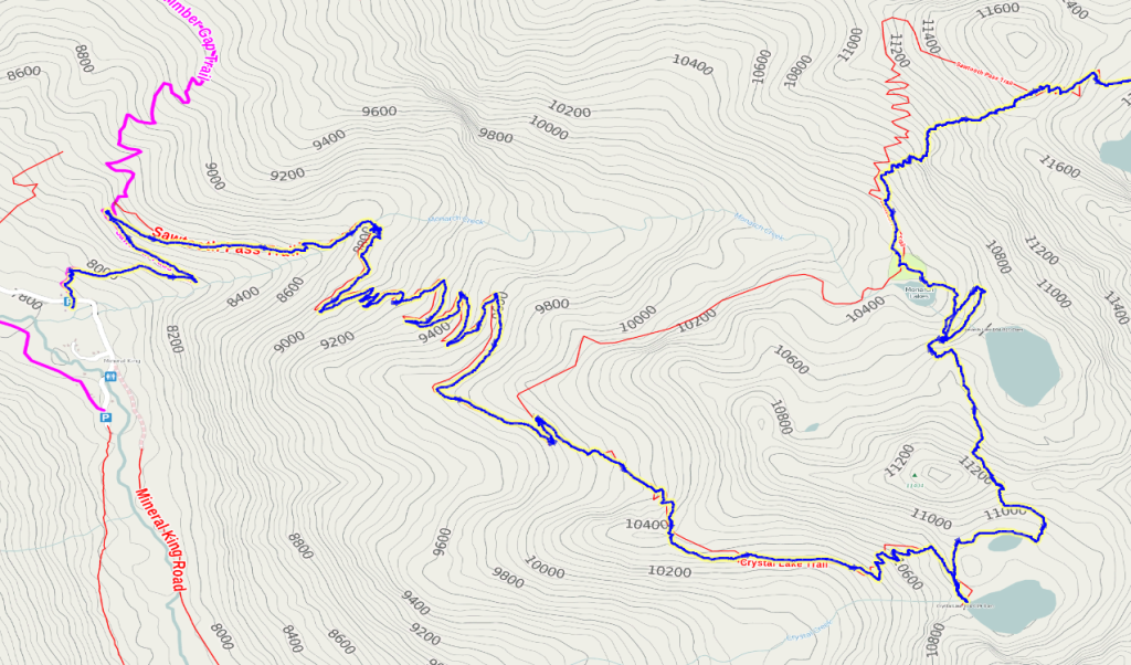
A short, class 2 off-trail section allows you to make a visit to Crystal Lake and Monarch Lakes. My route is in blue. I was informed of this route by an older man named David. Right at the Crystal Lake junction, he gave me directions to make the connection, which was fairly straightforward. My route is not the most efficient; He was going to take the regular trail to Monarch Lakes trying to get a look at Amphitheater Lake. After completing my loop, I saw him by Monarch Lake and ran over the rocks to thank him.
Most of this area was fairly crowded on an August weekend, so it didn’t have quite the feel of some of our other more remote routes. Nevertheless, it can still be enjoyed as a backpacking trip if you endeavor to camp away from Franklin Lakes and Monarch Lakes (the most crowded locations). Unfortunately, a number of the lakes were dammed, meaning a slightly less natural feel to the location. Once you turn off on the Mineral King road, it’s about 1 hour and 15 minutes to get to the trailhead on a one-lane road (that is partly unpaved near the top). Park passes are through a vending machine, but it was turned off because we were visiting on a National Park Free Day
Photo Gallery of the Route:
- Sooty Grouse seen near bottom of Granite Pass Trail
- Crystal Lake (back) and nearby tarn.
- Upper Monarch Lake
- Lower Monarch Lake
- Looking down on Columbine Lake from Sawtooth Pass
- Janet on Sawtooth Pass
- Heading down Lost Canyon
- Looking up Lost Canyon
- Looking up Soda Creek Canyon
- The shores of Little Claire Lake (good camping)
- Beautiful Florence Lake (Good camping)
- Looking up to Florence Peak and Franklin Pass
- Looking down Franklin Creek into Farewell Canyon
- Deer unafraid in Farewell Canyon
Links to maps and GPS tracks:


